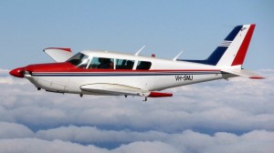
Our Comanche aircraft is fitted with a camera hole and when fitted with a ‘Specterra’ camera is used annually for aerial imaging of vegetation and measuring of cell density index in growing plants.
Aerial Imaging Benefits
Aerial Imaging allows a real time survey of the land in question and allows an informed assessment to be made of the nutritional needs or otherwise of the plants or crop.
This information can then be used to provide a prescription analysis and can be used in conjunction with a variable rate application of the recommended product/s.
Talk to us about your aerial imaging needs
Whatever your aerial imaging needs, if you are located within the Esperance Port Zone, we are confident that we can help you. Perhaps you have another aerial application need? Contact South East Air Ag to discuss how we can assist you.

